In 1930, Germany experienced the rise of a military state under the leadership of Adolf Hitler. The Luftwaffe (the German Air force) were early pioneers in the use of aerial imagery. Photographs were taken by Luftwaffe Aerial Archive of Great Britain & Ireland 1939 – 1942. German intelligence from both military and civilian flights. The Germans made considerable improvements in the technology, building specialist planes, revolutionary cameras and developing new films. The Luftwaffe were the leading exponent in the use of aerial reconnaissance photography. Imagery gathered prior to the war was used in the planning for the invasion of Poland, Belgium, France, Russia and Great Britain.
The Luftwaffe started to spy on the United Kingdom during 1936. Civil aeroplanes were adapted to carry secret cameras, photographing military and the economic centres of the United Kingdom. The German airship (the Hindenburg) made a tour of southern England conveniently flying over Plymouth and Portsmouth (Britain’s two main naval bases). A German intelligence officer on board the airship took pictures of the ships and facilities. The German intelligence during the pre-war years was so short of money that they sold souvenir copies of the picture to the British public to cover some of the cost of the photography.
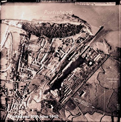
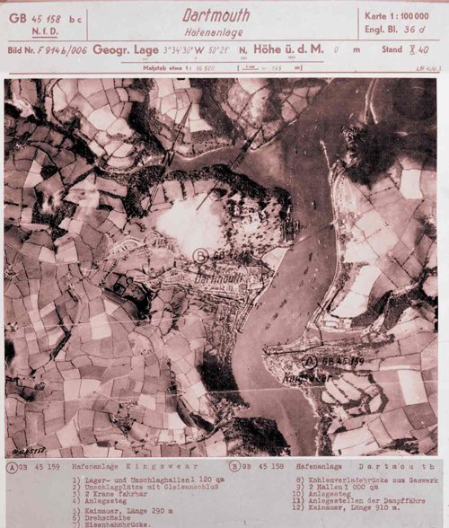
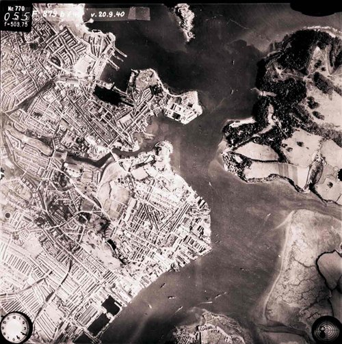
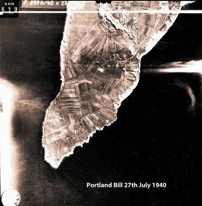
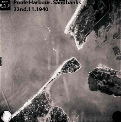
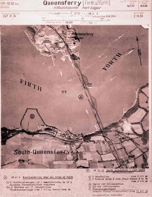
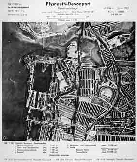
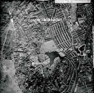
The Luftwaffe were thorough and efficient and photographed every part of the United Kingdom from Orkney to Cornwall and even included Ireland. They filed and interpreted the pictures. Factories, power stations, military facilities, reservoirs, ports, railway stations, airfields were all categorised, annotated and marked on the photographs. This was a huge undertaking and the first ever aerial survey of the United Kingdom.*
* The Royal Air Force did not undertake a complete survey of the United Kingdom till after the war, in 1947.
It is now over sixty years since these images were taken. Cities, towns, villages and the countryside have allchanged. The population of Great Britain in 1939 was 46 million compared to 61 million people now. Vast areas of the landscape have changed.
The Britain of 1940 did not have “out of town” shopping parks. The road network was mostly two lanes. Few people commuted to work. The industry and factories were in the centres of our great cities. Power was supplied by coal and the the coastal ports still handled cargo by crane and sling, and the railways dominated the distribution of goods.
In rural Britain farms were small and the fields were still the size to be managed by the horse and plough or small tractor.
On the 1st of January 1938, the German Defence Ministry established the 5th Abteilung of the Luftwaffe General Staff. This section of the Luftwaffe was to establish an intelligence operation to monitor the activities and capability of foreign air forces and prepare detailed target selection to be used in time of war. The targets were to include both military and the economic infrastructure of any potential enemy of the Third Reich. Major Josef “Bepo” Schmidt was the commander of the unit.
Most of the aerial reconnaissance photography of Great Britain was taken by the Luftwaffe between 1939 and 1942. The German High Command had realised early in the war the importance of up to date aerial intelligence. The German army had developed the quick “blitzkrieg” attack. This involved the rapid invasion of hostile countries using vast numbers of men and equipment. For the attack to work there was a need for accurate mapping and reconnaissance of landscape.
The Luftwaffe were well prepared for war and had a huge archive of reconnaissance pictures. The Luftwaffe had been gathering and collating aerial photographs of the UK since 1935 and by the outbreak of war had a photographic mosaic of the British Isles. In 1939 the Luftwaffe reconnaissance section had expanded and there were 23 long range reconnaissance units. Each unit had its own photo-laboratory where film was developed, analysed, printed and distributed. A master set of prints were sent to the central intelligence archive at Zossen (12 miles south east of Berlin). The central archive at Zossen was destroyed by fire during fighting towards the last months of the war.
After the war, the allies were able to examine the records of the Luftwaffe and were surprised at the number or errors in the German interpretation of the photographic material. Interpreters missed many crucial features. They failed to identify the British radar stations, which were crucial in co-ordinating the RAF defence of Britain.
The Luftwaffe never used stereoscopic viewers in the analysis of the images, which would have assisted in the interpretation of the pictures. The German Intelligence often relied on old aerial photographs, and after 1942 the planes used for reconnaissance were frequently attacked or shot down, disrupting the supply of images. By 1941 the Luftwaffe reconnaissance section was in decline, equipment resources became scarce and pilots on Luftwaffe bombing missions complained of the print quality of the aerial photographs, included in their target portfolios. The photographic interpreters were often fooled by camouflage and deception techniques used by the allies*.
*The ‘De Havilland’ aircraft factory at Hatfield was one of many industrial sites where the use of trickery clouded the interpretation of the aerial reconnaissance images. An illusionist carefully removed part of the roof of the factory and let off copious smoke canisters. A German reconnaissance aircraft flew over the industrial complex and from the resulting pictures taken the factory was downgraded from an important economic target to one that had suffered severe bomb damage.
At other potential target sites the allies also used canvas tanks, fake aircraft and empty oil barrels to disguise the landscape or encourage wasted bombing attacks.
Airfields were given dummy hedges and ploughed to look like farms and flares and oil drums were lit to mimic bomb damage. Often the image in the photograph lied and distorted the truth, and the judgement was down to the interpreter.
In 1937 the German Civilian airline handed over two civilian versions of the newly developed Heinkel He III to the Luftwaffe. The planes still bore their civilian airline markings; they were especially adapted and fitted out for spying. The engines were modified to make them faster and able to fly at higher altitudes and were fitted with hidden reconnaissance cameras.
The Dornier was one of a number of different planes used on reconnaissance missions. The aerial photographic section of the Luftwaffe was originally based at Oranienburg on the outskirts of Berlin.
The Dornier was designed as a civilian aircraft, an experimental high speed mail plane for Lufthansa. The plane was of metal construction and had a maximum operating ceiling of 26,400 feet and a top speed of 265 mph. The plane was rejected by the civilian airline due to the small cabin and difficulty passengers had in boarding.
The experimental aircraft was returned to the manufacturer (Dornier) and stored in a hanger where it was seen by a visiting Luftwaffe test pilot. After a trial flight, the pilot recommended that the plane be adapted for military service and it became the basis of a new German bomber and reconnaissance aircraft.
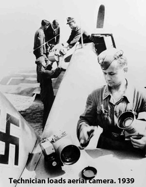
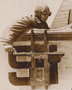
The reconnaissance cameras were developed by the Carl Zeiss company. The company used and adapted the technology from the film industry to produce sophisticated mapping cameras. The film was 35mm wide, with a perforated edge. The perforations allowed motors to turn the film automatically behind the lens of the camera which enabled a precise exposure and convenient film frames. Varying sizes of film were used for different conditions and special films and cameras were developed for night photography. The planes flew to 37,000 ft observing and photographing targets.
The films were unloaded at the end of a mission and sent to the attached Luftwaffe reconnaissance unit, where it was developed, collated and interpreted.
A portfolio of photographs and map extracts were prepared and supplied to the air crews at mission briefings. The photographs were annotated and marked with primary and secondary targets and any other information which was thought to be of use such as local landmarks.